
Remote Sensing Australia
Precision viticulture
For the past five years, Remote Sensing Australia has been working with grape growers and winemakers in both Australia and New Zealand, helping them to make their vineyards more profitable. We do this by providing expert support in the field of precision viticulture.
Click on the links below to jump to the relevant section...
- What do we do?
- What can I do with multispectral imagery?
- When is the data acquired and delivered?
- Do I need to be a precision viticulture expert?
- Weed mapping as well?
- So what's it going to cost?
- Australian Premium Viticulture Services
Factsheets
We have prepared three fact sheets which describe the work we do with the precision viticulture industry.
- Summary of our precision viticulture services (click here to view)
- Description of how remote sensing can be used to manage variability (click here to view)
- Profiting from variability by using split picking (click here to view)
What do we do?
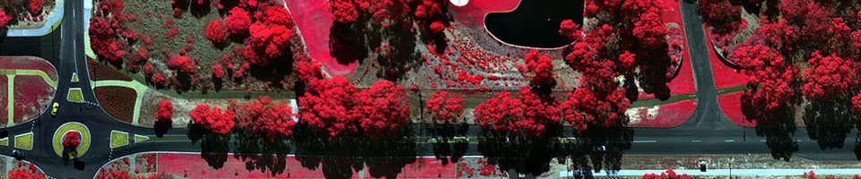
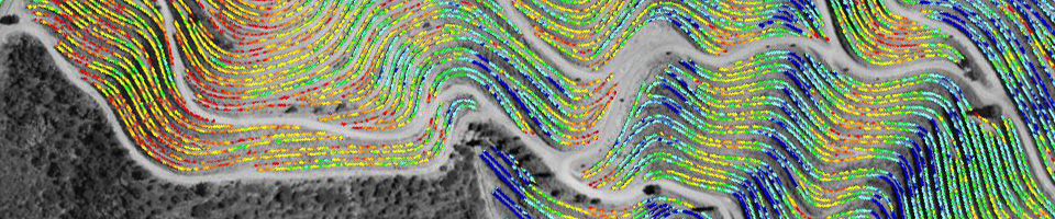
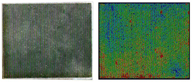
We use a manned aircraft (not a UAV!) to capture airborne multispectral imagery, which we then process with our own in-house developed software. We are able to accurately map the variability of vine health within the vineyard.
The image below on the left shows an aerial photograph of a vineyard. The image on the right shows the vine health (blue = low vigour; red = high vigour).
What can I do with multispectral imagery?
Multispectral imagery allows you to understand the variability within a vineyard. Our current clients use variability maps to either exploit variability within their vineyard, or to reduce it. Both approaches can significantly increase profits.
- Exploiting variability by split picking
Well-executed split picking can greatly increase profits, even from a small vineyard. Our variability maps are used to locate the boundaries between different quality grapes (A-grade, B-grade etc.), which can then be picked at different times, or into different bins. For more advanced split picking, we can also provide the same hardware and software as used by some of the biggest wine producers. Along with Hamilton Viticulture and Advanced Technology Viticulture we have recently launched "Australian Premium Viticulture Services" (PVS), which offers a complete split picking package. Please see below for more details.
To estimate the benefits of split picking, we have created an online split picking calculator, which you can find here.
- Exploiting variability to reduce inputs
Having a variability map of your vineyard will show you where you can safely reduce inputs without compromising the quality of the fruit. Reducing inputs where they are not necessary can make a vineyard considerably more profitable. Although many growers already have a 'mud-map' in their heads of where inputs can be reduced, multispectral imaging turns that mud-map into a scientifically rigorous map, which can be shared with staff and managers.
- Reducing variability by varying inputs
Over time, careful vineyard management can lead to a dramatic reduction in variability. Multispectral imaging can assist this process in two ways: by providing an initial variability map to highlight where variability needs to be tackled; and by providing annual maps to show the progress that has been made in reducing variability. Multispectral imaging is the only scientifically robust method of monitoring variability change over a long period of time.
When is the data acquired and delivered?
Multispectral imagery is flown twice a year: once at flowering, and again at veraison. Data is delivered within four days of the flight.
Imagery acquired at flowering is useful for reducing variability and reducing inputs, both in the short term and the long term. The data will show the underlying variability in the vineyard, caused by soil type, slope, aspect etc. It will show where work needs to be done over time to reduce that variability. But it will also show what can be done in the short term to reduce the variability for the current season. For example, at flowering there is still plenty of time to change watering regimes, and hence reduce variability.
Multispectral imagery flown at veraison is ideal for split picking. The imagery shows exactly where the different quality grapes are located. Using this imagery, along with some ground sampling within the vineyard, it is possible to create accurate split picking maps.
Do I need to be a precision viticulture expert?
Not at all! We work with both beginners and experts in precision viticulture. Our aim is to make this process as simple as possible. The three main steps in the processing chain (ordering, receiving, and interpreting data) are described below.
Ordering Data
Just go to the “request a quote” page on our website, and draw polygons around the blocks that you want flown. Within 24 hours we’ll send you a quote. As soon as we receive a deposit from you (50% of the total cost) we’ll add your blocks to our flight plan.
Receiving Data
We use modern technologies to keep the process of using data as simple as possible. You don’t now need to be GIS wizard to get a return on your investment. All data will be delivered in the following ways:
- online through a web browser (see an example here)
- on an Apple device (iPhone or iPad) using the "Mapsntrax" app
- on an Android device, using the "Backcountry Navigator" app
- Google Earth compatible files can be downloaded from our website
- raw data files can also be downloaded from our website
Interpreting Data
Interpreting variability maps is not difficult. Even so, we offer consulting support though our partners at Integrated Precision Viticulture. We can also supply documentation to help with the interpretation process, or we can put you into contact with other growers who are currently using multispectral imaging and variability maps.
Should you wish to implement a full split picking system, we can organise that through Australian Premium Viticulture Services, our joint venture with Hamilton Viticulture and Advanced Technology Viticulture (more details below).
Weed mapping as well?
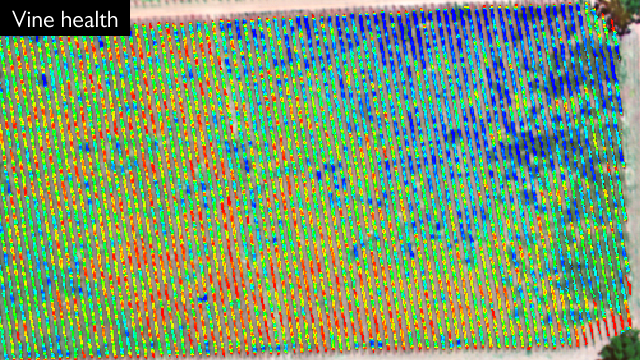
In addition to the usual plant cell density maps of the vines, we can also supply weed maps: maps showing the intensity of the vegetation (weeds) between the vines. This is a bit of a new product for us, so we’re not going to make any claims about how much more profitable your vineyard will become. But we can say that some of our current clients are very interested in these new maps. They tell another important story about what’s going on in the vineyard. Roll your mouse over image below to show the vine health map and the weed health map.
So what's it going to cost?
The cost for multispectral imagery is charged on a per hectare basis, with a minimum charge of 10 hectares, and discounts if multiple data sets are purchased. Included in each delivery is the following:
- variability maps delivered in a range of different formats (described above)
- technical support from our viticulture consultant partner, George Dridan from Integrated Precision Viticulture
The price structure is as follows:
- Single variability map, either acquired at flowering or veraison:
$30 per hectare plus GST (minimum 10 hectares) - Two variability maps (flowering + veraison, or flowering + weeds, or veraison + weeds):
$54 per hectare plus GST (minimum 10 hectares). This includes a 10% disocunt on the total cost. - Three variability maps (flowering + veraison + weeds):
$72 per hectare plus GST (minimum 10 hectares). This includes a 20% disocunt on the total cost.
Please note that we require a 50% deposit to be paid on ordering the data, and to balance to be paid on delivery of the data. We can accept credit cards through our online payment system.
Australian Premium Viticulture Services
As mentioned above, Remote Sensing Australia has teamed up with colleagues at Advanced Technology Viticulture Pty. Ltd. and Hamilton Viticulture, to create a complete end-to-end split picking consultancy service. We market this under the brand Australian Premium Viticulture Services (or PVS for short). Even if you have no experience in precision viticulture, we can help you to install and use the hardware and software needed to ensure you are gaining absolute maximum value from your vineyard through split picking. We provide:
- Hardware for split picking
- Digital multispectral imagery and PCD (plant cell density) maps
- Software for visualising variability in vineyards
- Consultation
- Full training and on-going technical support
If you would like further information about Premium Viticulture Services, please contact either Richard Hamiltion (hamilton.viticulture@bigpond.com, 0419 861 359), Bernd Kleinlagel (bernd@atv.net.au, 0423 210 652), or Paul Dare at Remote Sensing Australia.